February 15th – February 17th
We enjoyed our time in George Town for the past two weeks, but were ready to head further east or south and visit some of the less populated islands in an area our chartbooks call “The Out Islands.” Located within this collection of islands are several of the islands that Columbus supposedly either made his first landfall, anchored just off shore, or actually spent some time on the islands.
While we were not going to be able to visit all of them this trip, we did have a few in mind that we wanted to visit: Conception Island, San Salvador, and Long Island. If the weather cooperated, we’d hopefully get to visit those on this trip.
Based on the current forecast, we made plans to leave George Town just after sunrise, and travel the 40+ miles east to Conception Island as our first stop. We got up early Monday morning, made a good breakfast, completed all our pre-departure tasks, and pulled anchor right at 7am as planned and headed Eos out into the channel.
During our time in George Town we had met cruisers from three other boats that had expressed interest in spending some time in the Out Islands and possibly traveling together. Conception Island is approximately 40 miles east of George Town and unlike other passages the entire passage would be in open ocean rather than traveling just a few miles offshore and insight of land. So, there is some comfort in knowing a few other boats would be traveling the same path with us. When it came time to make plans for our final departure, one of the three other boats decided that they were going to remain in George Town a few more days and would not be able to join us on this trip. So, at 7 am Monday morning our little floatila of three boats got underway for Conception Island.

We motor sailed down the harbor and eventually made our way out into the ocean. The sky was clear, and the seas were probably running between 4 to 6’, and the wind was pretty much coming from directly on our beam (3 o’clock) so we had a great day for sailing across. Both of our other buddy boats sail considerably faster than Eos since they are both bigger boats and carry more sail area. As the day went on, they got further and further ahead. We eventually lost sight of them as they moved about 7 miles or so ahead of us, but we were able to electronically ‘see’ them on our navigation system.

Since they were both ahead of us, they reached Conception Island about an hour or so ahead of us and had their anchors down before we even entered the anchorage. The one good thing about being the last boat in the group to reach the anchorage was that we were able to call them on the radio and get ‘the scoop’ on the current depth of the water, good holding spots, etc.
We dropped our anchor a little before 4 pm and headed directly to the beach for a nice refreshing swim.
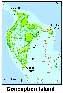
Conception Island is barely 6 square miles and rises to just over 60 feet. The entire island and surrounding reef system is part of the national park system is uninhabited. It too is a ‘no take’ area meaning that we’d have to leave any lobster or fish we might possibly see safely undisturbed in their habitat. (It’s not like the lobsters or fish really had to really worry about our hunting and fishing skills!)

Even though the island itself is uninhabited, the anchorage was not. Apparently, Conception Island has become popular with not only cruisers looking for an out of the way anchorage, but also with the mega yachts. We’ve heard that due to Covid and the pandemic, people who can afford to spend the +$100k/week or more that these boats rent for, are looking for secluded places like Conception Island to visit and avoid any crowds.
There were about 3 or 4 of these large yachts anchored in the harbor and while the boats themselves are massive, the people renting them appear to only have a few people traveling with them. So, we didn’t have to worry about running into crowds on the beach either!

After a relaxing swim on the beach, we returned to Eos for the evening. We made plans with our buddy boats to meet up just before high tide the next morning for a dinghy excursion through the mangroves.
The next morning, as agreed, we were all ready to go just before high tide (10 am). One of the other boats had a really big dinghy and motor to go along with it and offered to serve as the tour boat for the day. The entrance to the mangroves was about 2 miles or so south of our anchorage. There was a small, less than 100 feet wide, cut or opening in the shore line that led to a series of creeks and lakes in the interior of the island.

Our ‘tour guide’ did a great job of navigating the entrance, reading the surf, and picking out just the wave to ride through the entrance. Once inside the mangrove area, the water was calm and crystal clear. We could see small sand sharks and turtles swimming in the water alongside us as we motored along.
We spent a good hour or so exploring the waters and then found a good spot to ‘park’ the dinghy and go ashore for a hike and land exploration. During our hike we found the ruins of what was apparently at one time a small settlement on the island. We looked to see if we could locate a guest book with Christopher’s signature but didn’t find one lying around!

After an hour or so on land, it was time to get back in the tour boat and make our way back through the cut and then return to our boats. Again, the guy driving did a great job getting us out, but heading directly into the waves and surf this time, the ride out was a lot ‘wetter’ than the ride in.
Thoroughly soaked and tired from hike/excursion, we all enjoyed nice long naps once we returned to our boats. After a rest, Diane and I took our dinghy ashore and explored the northern end of the island by ourselves for awhile. We had a nice hike, found several nice vantage points to look at both the boats anchored along the western shore and also some places to see the east coast line of the island. Looking eastward and seeing the rocky coast, one can’t help but wonder how the early explorers like Columbus ever made it safely around these islands without running aground or into the rocks.
Later that evening, our small floatilla all gathered on one of the other boats for dinner and made plans to sail north to Cat Island the following day. According to the forecast, the winds would be shifting in a day or so that would make the anchorage off Conception very uncomfortable, so we all decided to move to Cat Island for better protection from the upcoming wind and potential surge from the waves.


Some pictures of the beaches on Conception Island


Wow! What great stories and pictures. Keep sharing your adventures, we love reading them and seeing all those beautiful warm climate pictures while there is snow on the ground here.
LikeLike
Thanks June. Glad you all are enjoying along with us. Next year you’ll have to make plans to join us in person.
LikeLike